Project Background
Marine Recreational Fishing (MRF) provides significant economic, cultural, and ecological value worldwide, yet its sustainability is challenged by limited data on fishing effort, catch, and ecosystem impacts [1]. In Norway, MRF—especially by tourists targeting species like Atlantic cod (Gadus morhua) and pollock (Pollachius virens)— generating notable economic value for local communities. However, the sustainability of these activities is a growing concern while governance and data integration gaps hinder effective management [2].
Citizen science offers a cost-effective way to improve MRF monitoring by involving anglers in standardized data collection [3]. Norway has pioneered self-sampling, tagging, and app-based reporting aligned with ICES and EU guidelines [4], but participation and data resolution remain challenges highlighting the need for innovative tools and engagement initiatives [5].
In this context, the independent ACCESS-Fjord project by Terramare Fjord & Gård AS was launched to combine recreational fishing with real marine research with the aim to generate scientifically useful data on fish populations and environmental conditions — while offering visitors an unforgettable hands-on experience.
Core ideas:
- Every fishing trip is also a scientific survey.
- Every guest becomes a contributor to knowledge about the fjord ecosystem.

Study Area: Sørfolda Fjord system
The sub-Arctic Sørfolda fjord system in Northern Norway, is a dynamic and ecologically important coastal environment. It remains ice-free year-round and features a deep basin (574 m) with a sill depth of 265 m, creating strong stratification and limited water exchange [6]. Freshwater runoff from rivers and glaciers drives estuarine circulation and seasonal variation in salinity and temperature. Commercial fishing is present but limited due to steep topography and deep basins, while local activity is mainly small-scale angling targeting cod and pollock. Sørfolda serves as a key spawning and nursery area for Norwegian coastal cod, whose retention is influenced by fjord circulation and hydropower-regulated freshwater flow [7]. The fjord also supports diverse benthic communities shaped by sediment and hydrographic variability [8]. The presence of multiple aquaculture sites and related environmental pressures [9] underscores its importance for integrated marine research and conservation.

Ecotourism-Based fishing survey
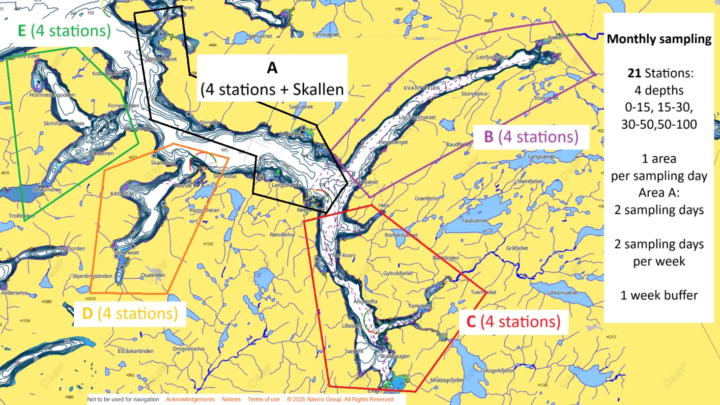
A random-stratified sampling scheme is applied across five predefined areas (see map below), allowing the full survey to be completed within one month and ensuring monthly-resolution data. Stations are distributed across predefined depth layers (0-15 m, 15-30 m, 30–50 m, 50–100 m). At each station, visitors become part of the research team — fishing, collecting data, and taking simple environmental measurements under the guidance of onboard scientists, experiencing firsthand what a real marine survey feels like. Tasks are designed to be simple and engaging to maintain both data quality and visitor enjoyment.
At each station we record:
GPS position, exact depth and tide level
Time, weather, and sea conditions
Fishing technique (bait/lures) and fishing time
Number and species of fish caught
Individual length and weight
Temperature and salinity using a CTD logger
Reel4Science App: from raw data to advice

The data we collect will help address fundamental ecological questions supporting the broader goal of ecosystem-based fisheries management.
To achieve this, we developed an interactive educational platform designed to show visitors how their fishing experiences contribute directly to real marine research. Each fish caught, measured, and recorded through the project becomes part of a powerful scientific workflow — from raw data to stock assessment and management advice.
Try the App here: Reel4Science
The app visualizes every step of this process in an intuitive way. Visitors can explore catch data on interactive plots, view trends in catch per unit effort (CPUE) or examine length–weight relationships and length frequency distributions. From these data, the app allows to generate size-based indicators and run simple yield-per-recruit (YPR) analysis and stock assessment models to estimate fish population status, fishing pressure, and sustainable harvest limits. Environmental data collected alongside fishing activities are also integrated, allowing users to see how temperature, salinity, and other factors influence fish populations.
By translating raw data into scientifically valid indicators, the platform demonstrates the potential of citizen science to enhance monitoring, support adaptive management, and improve sustainability in coastal fishery systems — fully aligning with ICES and EU calls for standardized, continuous MRF data collection to strengthen ecosystem-based fisheries management [10].

Benefits and Impact
The project will generate high-resolution, year-round data, in support of sustainable fisheries management and ecosystem-based conservation while enhancing scientific understanding, environmental stewardship and community engagement. By bridging tourism, community engagement, and marine science, this model can serve as a blueprint for integrating fisheries management, conservation, and experiential tourism in Norway and beyond.
Watch the full first presentation of our project delivered at Stockholm University’s Marine Lunch Seminar here:
Join Us
By joining our initiative you are not only booking a holiday — you are joining a scientific survey.
Your participation helps us collect meaningful ecological data, strengthen community science, and safeguard the natural heritage of Norway’s fjords.